


Callaway Twp. Voting District, Becker County, Minnesota
About
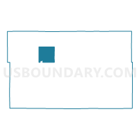
Outline

Summary
| Unique Area Identifier | 601085 |
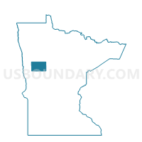
| Name | Callaway Twp. Voting District |
| County | Becker County |
| State | Minnesota |
| Area (square miles) | 35.36 |
| Land Area (square miles) | 34.17 |
| Water Area (square miles) | 1.19 |
| % of Land Area | 96.64 |
| % of Water Area | 3.36 |
| Latitude of the Internal Point | 47.03494300 |
| Longtitude of the Internal Point | -95.86738950 |
Maps

Graphs
Select a template below for downloading or customizing gragh for Callaway Twp. Voting District, Becker County, Minnesota


Neighbors
Neighoring Voting District (by Name) Neighboring Voting District on the Map
- Callaway Voting District, Becker County, MN
- Hamden Twp. Voting District, Becker County, MN
- Maple Grove Twp. Voting District, Becker County, MN
- Riceville Twp. Voting District, Becker County, MN
- Richwood Twp. Voting District, Becker County, MN
- Spring Creek Twp. Voting District, Becker County, MN
- Sugar Bush Twp. Voting District, Becker County, MN
- White Earth Twp. Voting District, Becker County, MN
Top 10 Neighboring County Subdivision (by Population) Neighboring County Subdivision on the Map
- White Earth township, Becker County, MN (828)
- Richwood township, Becker County, MN (662)
- Sugar Bush township, Becker County, MN (504)
- Maple Grove township, Becker County, MN (455)
- Callaway township, Becker County, MN (287)
- Callaway city, Becker County, MN (234)
- Hamden township, Becker County, MN (206)
- Spring Creek township, Becker County, MN (114)
- Riceville township, Becker County, MN (83)